48 · Jalisco, Mexico
Bosque La Primavera
Guadalajara's training forest: a 17 km loop of dirt road and single-track through pine and oak, 2.2 km inside the Mariano Otero gate, on the course of the city's own trail race.
MEXICO
Área de Protección de Flora y Fauna La Primavera (federal decree of 6 March 1980, 30,500 ha; UNESCO biosphere reserve since 2006)
20° 37' N103° 28' W
Site grade
Easy mediumFeatured400 m of gain over 17 km with a high point of 2,086 m: nothing steep for long, and nothing technical beyond loose ground on the descents. The heat and the fire season are the real constraints.
The experience
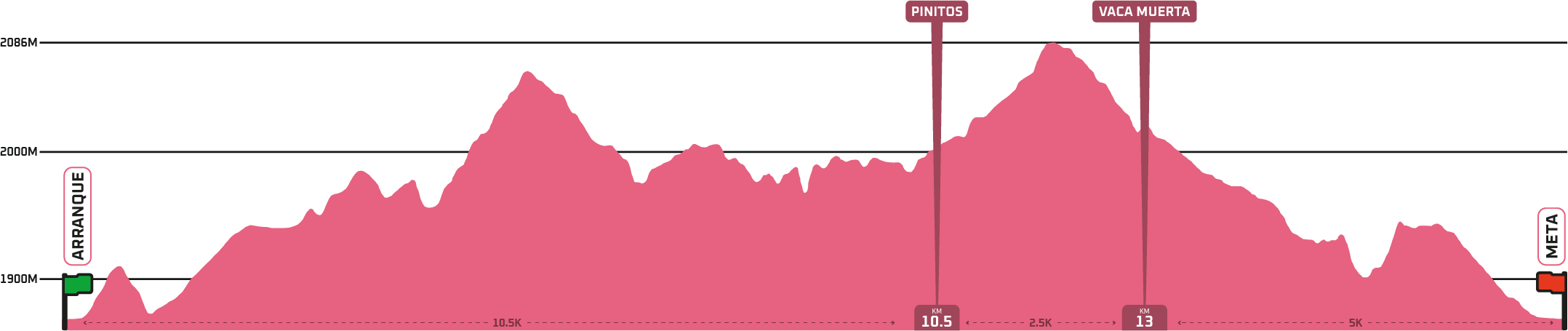
The Cañadas loop is 17 km with 400 m of gain, all of it between 1,900 and 2,086 m on dirt road and sandy single-track. Nothing is steep for long. The ground is volcanic pumice that runs fast and slides on the descents.
It is a working forest, not a park: the roads are shared with cyclists at 25 km/h, the gate at Mariano Otero opens at 7:00, and the biggest risk on the calendar is fire in the dry months.
The forest was decreed a federal protected area on 6 March 1980 and named a UNESCO biosphere reserve on 27 October 2006. It is administered by a state public body, the OPD Bosque La Primavera, in agreement with the private owners and ejidos who hold the land. Mountain biking has been practised here for more than 30 years, which is why the OPD's visitor pages are written for cyclists first.
Where the sources disagreeThe OPD rules published in 2026 give general entry 8:00 to 17:00 with stays until 18:00, and at Mariano Otero entry 7:00 to 17:00 with stays until 19:00; in March 2026 the OPD said vehicles enter at Mariano Otero only from 7:00 to 13:00. The Cañadas loop is marked only on race day; the rest of the year you follow it by GPX from the organizer's Wikiloc embeds, and the OPD requires you to stay on roads and paths open to the public. Fire is banned all year, and the forest burned in April 2019; do not run it in smoke. The forest is private and ejido land inside a federal protected area, and the OPD warns that all activities are at the visitor's own risk. Whether a per-person fee is charged at the Mariano Otero gate is not stated in the OPD's current rules; carry cash for it.
Trail path
The line
you follow.
- 01Pic-nic RC Club
- 02Reserva La Cuesta
- 03Espinazo
- 04Pinitos (km 10.5)
- 05Vaca Muerta (km 13)
- 06Pic-nic RC Club
Route sections
Wide dirt road and sandy track out of the club and through the Reserva La Cuesta. Runnable and exposed; this is where the sun finds you after ten in the morning.02 · The First HumpEspinazo to Pinitos
The Espinazo ridge lifts the loop to a first crest near 2,050 m and drops it again. Pinitos, at km 10.5, is where the organizer puts the marker.03 · The 2,086 LinePinitos to Vaca Muerta
A 2.5 km climb to the loop's high point at 2,086 m, then the drop into Vaca Muerta at km 13. The pumice is loose; this is the section runners talk about.04 · The Five HomeVaca Muerta to Pic-nic RC Club
Five kilometres down, with one short climb before the club. Cyclists share these roads; keep right on the bends.
Weather profile
What the sky
is likely to do.
Dry and warm from November to May, with the fire season at its worst in March, April and May; rains from June to October make the pumice firm and the mornings cool. Sun exposure on the sand roads is the daily problem.
Season & timing
Signature moments
What you will
remember afterwards.
The gate opening at 7:00 with cyclists already queued
Sand roads through the Reserva La Cuesta
The high point after Pinitos
The pumice drop through Vaca Muerta
HECTARES
30,500A federal protected forest on the city's west edge
The OPD Bosque La Primavera states that the Área de Protección de Flora y Fauna La Primavera was decreed on 6 March 1980 with 30,500 hectares across Zapopan, Tlajomulco, Tala and El Arenal, and became a UNESCO biosphere reserve on 27 October 2006.
Access & logistics
Key hazards
- ▲Fire and smoke in the dry season, with an all-year ban on any fire
- ▲Cyclists on shared dirt roads, speed limit 25 km/h
- ▲Vehicles on the main road until 13:00 at Mariano Otero
- ▲Loose pumice on the descents
- ▲No water on the loop
- ▲Heat and sun on open sand roads after mid-morning
SafetyOrientation only. Always use current official maps, alerts and safety guidance. Start at opening, carry all your water, keep right for cyclists, and stay out of the forest when there is smoke.
We track ground truth. Send a field note after your run: three photos, ground condition, the signature moment, the local anchor.
Official sources
- 01bosquelaprimavera.jalisco.gob.mx
- 02bosquelaprimavera.jalisco.gob.mx/reglamento
- 03bosquelaprimavera.jalisco.gob.mx/archivos/Reglamento/Reglamento_decalogo.pdf
- 04www.ultrailmexicoseries.com/la-primavera
- 05www.ultrailmexicoseries.com/wp-content/uploads/2026/01/MAPA-CAÑADAS-17K.png
- 06primavera.v3.livetrail.net/es/2026
- 07jalisco.quadratin.com.mx/principal/bosques-urbanos-y-la-primavera-anuncian-actividades-para-vacaciones
- 08bosquesamg.mx/informan-ambu-y-opd-la-primavera-horarios-especiales-para-periodo-vacacional-en-parques-y-bosques
- 09www.openstreetmap.org/node/9859495210
- 10commons.wikimedia.org/wiki/File:Wildfire_in_the_%22Bosque_de_la_Primavera%22,_Jalisco,_Mexico_-_April_13th,_2019_(47604413391).jpg
- 11commons.wikimedia.org/wiki/File:Bosque_de_la_Primavera,_Jalisco.jpg
.jpg)

Last verified 2026-09-16 · Record CETC-RUN-048 · Orientation only. Always use current official maps, alerts and safety guidance.
Photograph: Mexikansi72 · CC0